Taken from : http://dh-web.org/place.names/#C
| hadayantalawa, Chadayantalava (Ampara) DADAYANTALAVA ⚓name "This means "Hunting plane" and the sinhala "The-ද" has become Tamilzed to "Cha". The name "Dadayanthalaava" was correctly used even in 1948 | දඩයන්තලාව |
| Chaddi, Chaaddi, Catti, சாட்டி (Jaapanaya [Jaffna]) VAADIYA ⚓name This is a small coastal location on the Urathota (Kayts Island) shore. "Vaadiya" is used to designate a hut or encampment associated with fishing or agricultural activity. By extension, it can apply to a tract of land used in farming, pasturage etc. Thus we have "parana-vaadiya" (Old-encampment), and "Thanamal-vaadiya" (Tract of flowering-grass), "Kurakkan-vaadiya"(chena of Millet) etc, in various parts of the country including the eastern province. -- The very small old-town area near the Bentota tourist complex, (southern province) was originally known as "Vaadiya" as it started as an oyster-fishery complex (but inhabited by social groups not associated with fishing "castes", as well as sinhala families with Dutch names, e.g., van de Bona). In the early part of the 20th century "Vaadiya" in Bentota had a small "Rest house" and the "main street" itself was known as "Vaadiya". A remarkable Dutch church which existited till 1960, and used as a school, was unfortunately demolished by a government which had no sense of historical monuments. A Buddhist temple on a hillock (Udakotuva Vihaara) is of historical significance, but has no known ancient artifacts. This temple, and the more celebrated "Yaathramulle temple" a few kilometers away, had monks who taught Wilhelm Geiger, Rhys Davis and other western Pali pioneers. -- It should also be noted that the form "kumburu-kattiya" may be used for a "tract of paddy land", and "kattiya" is probably derived from the Pali (c.f., Kottaasa). It means a tract or division (of land in the present context). Thus "chaddi" could also be related to "kattiya". The root of the word in Dravidian etymology may well be in the Sanskrit from of "Kotthaasha". Interestingly, the usage of the word சாட்டி cāṭṭi; in Tamil is more commonly for "Land lying fallow after a crop" (see Madras Tamil Lexicon, p 1356). The place name "Chaddi" in Urathota shore is mostly likely derived from වාඩිය, i.e., the location of a fishing encampment. | වාඩිය |
| Chalai Challai (Mooladoova[Mullaitivu] THALAAVA ⚓name, TALAWA This is south of Punnainiravi and north of Chundikulum Note that the tamil "thillai" is used for a type of mangrove, Excoecaria agallocha but we believe that this is not the basis of this toponomy. The word may also have come from the Sanskrit "Saila", i.e., stone, or from the sinhala "Daella", squid shells. But 'Thalaava' is toponymically our preferred choice for this location. [On the other hand, the place named 'Galle', the capital of the southern province may have arisen from 'Saila→Gala→Galla', ගාල්ල.] See map of Punnainiravi and Chalai | තලාව |
| Challi-munai (Gonakanna [Trincomalee]) Sailamunna, GALMUNNA ⚓name 'Challi' is from the Sanskrit 'Saila', sinhala 'silaa' for stone. The word 'Gal' may have also originated from 'Chall(i)→Gal', while a Sumerian source has also been proposed! The stones may be limestone, coral stone etc. Similarly, there is a Challik-kalappu or "Galkalapuva" (stoney lagoon) in the same area. | ගල්මුන්න |
| Challik-kalappu (Gonakanna [Trincomalee]) GALKALAPUVA | ගල්කලපුව |
| Challitivu (Madakalapuwa [Batticaloa]) GALDOOVA, Sailadoova This was originally a small group of reefs and rocks, now damaged and also enlarged into an islet during the 2004 Tsunami. It represents a very fragile eco-system, and is located in the Madakalapuva lagoon. It should not be opened up for tourism. | ගල් දූව |
| Chalampan, Chaalampan (Mannaram[Mannar]) SAALAPANA ⚓name , SAALAVANA Disc. The Sal tree, Bot., shorea robusta is a timber tree with fragrant flowers and 'canon-ball' like fruits. Botany Page Sal is either the "cannon ball tree", or the related north Indian diperocarpaceae referred to as 'Salva', 'sakhu', 'shal' and also 'kandar' Sanskrit and pali names are also Saala. The names 'saala', and also 'Sal' are used in Elu-Sinhala, modern Sinhala and in north Indian languages. In Tamil Nadu, 'chaalamban' is a soft-wood tree, '. The 'Sal' tree itself is called 'Kungkiliyam' (p 954 of the Madras Tamil lexicon). See also Kunturukkam, p996 of MTL. Thus the use of 'Chala' in the place name clearly supports the derivation of the Lankan-Tamil form 'chaala' from the sinhala 'saala'. The tree has a special place in Buddhist belief and lore, as Prince Siddhartha Gautama, the future Buddha, ia claimed to have been born in Lumbini park, (in modern Napal), under a Sal tree. Similarly, the Parinibbana (passing way) is said to have taken place in a grove of Sal trees in Kusinara (Kushinagar) of the Malla kingdom. The Sal tree when tapped, yields white opaline resin which is burnt as incense in Hindu/Buddhist religious ceremonies. It is also used for caulking boats. The seeds are used for oil extraction. The hardy wood does not take a polish and is used in heavy construction. An oil obtained from the sal fruit is used in lamps. The Sal tree is an object of worship among Buddhists and Hindus. The tree "Vateria indica", Skrt. 'Sarja', is known in Tamil as Kundirikam or 'kungilium', dhup-maram, and may be confused with the "sal' tree. Map සාලපන | සාලවන |
| Chalampan (Chinnach-), (Periya-) சாளம்பன் (Mooladoova[Mullaitivu]) SAALAVANA (kuda) (Maha) SAALAVANA ⚓name for this entry See Disc. under 'Chalampan' in Mannar. | සාලවනය (කුඩා-), (මහ-) |
| Chalampaikkulam (Vannimava[Vavniya]) SALGASVAEVA ⚓name See discussion under Chalampan Map | සල්ගස්වැව |
| Chalampakerni, Chaalampaikkeani (Madakalapuva[Batticaloa]) SAALAKAENNA ⚓name See discussion under Chalampan There is also a'Saalahena', i.e., 'Chalampaicheannai' in this area. 'SaalaKaenna' is a dug-out region, near a forest of Sal trees. Sal is either the "cannon ball tree", or the related north Indian diperocarpaceae referred to as 'Salva', 'sakhu', 'shal' and also 'kandar' 'Kaenna' is from the sinhala 'kaeneema', to dig. Map | සාලකැන්න |
| Chammalai (Mooladoova [Mullaitivu]) GAMMALE ⚓name, Gammmalé The word " malé " has been used since ancient times in Sinhala to indicate hilly or mountainous regions. Thus "Kothmalé" is referred to in the story of Prince Gamunu (later Dutugamunu), 2nd century CE. The word is derived from the Sanskrit use of Mleccha, and Pali Milakkha to mean barbarian or hillman , (e.g., p. 533 of the Pali Text society dictionary). See also Geiger, Pali Grammar p622, Milaaca [by-- form to milakkha, via milaccha → milacca → milaaca". The above usage in Pali and Sanskrit, for hill tribes ("non-Aryans=barbarians"), suggests that the word "malé", or " malaya " found in modern and old Sinhala for "hilly region" probably came from these source languages. The form "malai" found in Tamil dates to the Changam period, and may have also arisen from Sanskrit sources. The contention by T. Burrow and M. B. Emeneau, (A Dravidian etymological dictionary, Oxford 1961, p. 314) that malai is an original Tamil word, because it occurs in Sangam poetry, is untenable as the Sanskrit sources are older. Karthigesu Indrapala's claim (p 375, The Evolution of an Ethnic Identity, Chennai 2006) that "some of the early geographic names in the Pali chronicles also seem to indicate the influence of Dravidian languages", is also based on the erroneous Burrow-Emmaneua etymology of "malaya", and possibly "pattana" (see entry under "Yapapatuna"). This village is part of the Weli-oya development area | ගම්මලේ |
| Chammanthurai, Samanthurai, Sammanthurai சம்மாந்துறை (Ampara) SAMANTHARA ⚓name See discussion under: Samanthurai | සමන්තර |
| Champoor, Sampur சம்பூர் (Gokanna [Trincomalee]) SOMAPURA ⚓name See entry under Sampur | සෝ මපුර |
| Champuththurai, Camputurai (Yapanaya[Jaffna]) JAMBUKOLA ⚓name This is on the mainland near the causeway to Karainagar. Disc.-The name suggests that this may have been the 'Jambukola' of the Mahavamsa. Kankesanthurai is also a candidate for the Mahavamsa port. See entry under Kankesanthurai | ජම්ඹුකෝල |
| Chamalankulam (Vannimava [Vavniya]) SAMALAN-VAEVA, Halmillavaeva | හල්මිල්ලවැව |
| Camulaiyativattai, ChamulaiyadiVaddai, சமுளையடி வட்டை (Madakalapuva[Batticaloa]) HALMILLAVATTA Disc.- 'Halmilla' is sinhala for 'Berrya cordifolia' and is close to the Tamil name 'Chamandalai' for this valuable timber tree. | හල්මිල්ලවත්ත |
| Chandilipai(Yapanaya[Jaffna]) See Sandilipai | සන්දිලිපේ |
| Chandrapuram (Yapanaya [Jaffna]) CHANDRAPURA | චන්ද්ර පුර |
| Chankanai, Sankanai (Yapanaya [Jaffna]) CHANDANA 'Chandana' means Sandalwood in literary S., from Pali. See Gomarankadawala regarding "Sandun Kumara" cult See Old Dutch map, Changana Base Hospital map | චන්දන |
| Chankattarvayval(Yapanaya[Jaffna]) SANGATARAVYA Disc. -'cankattaar' in Tamil refers to 'Buddhist and Jian fraternity of monks, c.f., Madras tamil Lexicon, p1222 'Sangataravaya' would be the side, or promenade allocated to the monks. Compare also with the name "Hanguranketha ← Sanga-sathu-ketha" See Jaffna area Map. | සංගතරවය |
| Chankaththanai, Chankattanai (Yapanaya[Jaffna]) SANGASTHAANA This is close to Chankattarvayval and was probably a part of a larger Buddhist complex. See entry under 'Pachchilaippalli' (Paththirapahala) which is nearby. 'Thaenna' is a common sinhala ending for 'place', location In pure tamil the usage is '(s)thaanam', and the form 'thanai' found only in Sri Lanka is probably a sign of adaptation from Sinhala. | සංගස්තානය |
| Chavakachcheri, Chaavakachcheari சாவகச்சேரி (Yapanaya [Jaffna]) JAAVAKACHERAYA, Chavakachcheriya, Javakachcheri Sinhala Meaning. Area where Javanese people lived, "Java town" According to the Mahavamsa, Chandrabhanu, a Javanese ruler from Tambralinga invaded SL in the 13th Century CE. His armies landed in Gokanna(Trinco), and used blow pipes and poisoned arrows, and ruled Jaffna for three decades. Tambralinga is in the south isthmus of Thailand, close to Malaysia. Jaffna or Japané was a main Javanese settlement left behind by Charndrabhanu. The largest Buddhist shrine to God Natha was in Chavakakachcheri (Javakachcheri). It was destroyed by the Portuguese. Natha, or "Naaka" was the God of the Naga people who lived in Nagadeepa, the ancient name of the Jaffna peninsula as found in the Pali chronicles. See entry under Jaffna. See Dutch Map, Chiavagacherij, Chavakgatzeri, Chawagacheri see Jaffna map1 Politics.There was a noteworthy Muslim presence in Chavakachcheri. Some 500 Muslims were expelled on 25th October 1990 with just two hours notice by the LTTE. They were a part of the 85,000 muslims expelled from the North. By the year 2000 most of the city had been destroyed by the war. See muslim expulsion S. Kadirgamar on the "Final Report of the Citizens’ Commission on the Expulsion of Muslims from the Northern Province by the LTTE in 1990 This is the birth village of Thamilselvan, spokesperson of the LTTE since the demise of Anton Balasingham. Tamilselvan was kill in Nov 2007 V. Kumaraswamy was the first MP of this seat in the first general election, 1947. | ජාවකච්චේරිය |
| Chavatkaddu, Chaavatkaddu, Cavarkattu" சாவற்கட்டு (Yapanaya[Jaffna]) JAAVAKADUVA Disc.- This was another area in the peninsula where the Javanese people inhabited, and developed a tradition of boat building. Boat building has existed here even in recent times. See also entry under place name 'Chavalkaddu' | ජාවකඩුව |
| Chavangkoddai (Yapanaya[Jaffna]) JAAVANG-KOTTE, Ja-kotte This is a fortification associated with the Javanese. Charndrabhanu II used this fortification to fight the Magha. Seee entry under Chavakachcheri | ජාවකෝට්ටෙ |
| Chavalkaddu (Mannaram[Mannar]) HABALKADUVA This is a ferry point, and 'habal' in Sinhala is "Oar' In tamil 'cavalakkaarar' is a ferryman. Caaval is a male cock and 'caavar-kattu' is a cockfight ( see p1339, Madras T. lexicon), but there is no tradition of cock-fighting here. See under Chavalakkadai for other details of the word "chaval" and Saevul. | හබල්කඩුව |
| Chavalakkadai, Chaavalkkadai(Madakalpuva[Batticaloa]) KUKULKADE, SAEVULKADE (anchor name) 'Chaaval' or Chaval is a rooster in Malayalam and Tamil, 'Kukula' in Sinhala (kukkuta in Pali). The Malayalam word has been admitted to sinhala in the form "saevul", as in the "Saevul sandesha" of Alagiyavanna Mukaveti (Alagiawanna Mohottala, 17th century). The earliest literary use of the word "saevul" in sinhala is probably found in Thotagamuwe Sri Rahula's 15th century work, composed during the time of Parakramabahu VI, named "The Nightingale's Message (or Epistle-Poem)" Salalihini Sandeshaya; verse 25 line 2, "rane- yataga savulindu dada ga_lapa-ya". Sri Rahula and others See also entry under 'Chavalkaddu' Map | කුකුල්කඩේ සැවුල් කඩේ |
Cheddikulam, Chettikulam, Vettikulam (Vavnimava [Vavniya]) HETTIAEVA, GEDIWEWA Labeled #110 in Vanni Buddhist sites map For label no: 111 click here For label nos: 112, 113 click here For label nos: 114,115,116 click here Ancient Buddhist ruins, Listed in 1982 by Archaeo. Dept. Somasiri Galara (Kalaru) stream and several private lands are included in this list. Some 500 acres used for tobacco farming contain ancient ruins, remnants of a large stupa, old bricks, stone pillars etc. Meaning Tamil, 'cheddi'=community 'Hetti' or 'Chetti' was a merchant community cited even in the Pali texts Type of report filed with Canadian Govt reg. army checkpoint | හෙට්ටිවැව |
| Cheddipalayam, Chettipalayam (Madakalapuwa [Batticaloa]) KADAPEELIYA, KADAPALA Meaning S. 'town area' ; T. could mean'community place' Tsunami | කඩපල |
| Cheddiyakurichchi, Chettiyakurichchi (Giranikke, [killinochchi]) HETTIYAKULISSA Meaning: Kuliya, Kulissa or 'pattuwa' in S., and 'Kudiyiruppu' T. are words which may mean 'quarters', or 'ethnic area' The word `Kuli' was used in old sinhala for hamlet or village. 288 the verse (9th century), Sigiri Mirror-wall – "I am Gunakara (of) Ambagam-kuli (of the) Northern Province Clear map of area near Yapana lagoon | හෙට්ටිකුලිස්ස |
| Cheddukulam, Chettukulam (Mannarama) KEHETUVAEVA See military Action-2008 map near Mannar | කෙහෙටුවැව |
Chelleivillu (mooladoova[Mulaitivu]) SAALIYAVILA Labeled #31 in Vanni Buddhist sites map Ancient Buddhist ruins, Listed in 1982 by Archaeo. Dep. Somasiri | සාලියවිල |
| Chempankundu(yapanaya[jaffna]) KUMBURUKANNIYA Now included in the Killinochchi administrative region. This is located between Punranna(Poorneryn) and Palaava(Palavi) Disc.- 'Kanniya' is a small tract of land. 'Kundu' in T. could mean the same thing, but 'chempan' cannot be ascribed a meaning. Perhaps 'Kumburu'→chumpuru' etc ? see Jaffna area map Regional map | කුඹුරුකන්නිය |
| Chempian aru, Chempiyan pattu (Yapanaya [Jaffna]) SEMBIAN-oya, SEMBIANPATTUWA, Choranaaga oya, choranaga pattuva Meaning The Cembians are a caste associated with the Vanniyars (Vanna-kula) of Chennai. The forms 'Chempian, chempiyan', may also be a name of a queen, 'Sembian Devi', wife of Gandaraditya Chola (10th Cen.) However, Tambra in Tambraparni is (according to Rasanayagam) equivalent to "Chembu" in tamil, "Chempian pattu is `Tambarapattu'. Furthermore, the Chola King Karikala is said to have been named `Chembiyan' after his uinvasion of `Tambraparni'. This name would have been instated in the 15th century or afterward. The ancient name is believed to be 'choranaga oya'. | සෙම්බියන්ඔය, -පත්තුව |
| Chenaikudiyiruppu (Ampare) SENAAKUTIYA Meaning: In Tamil, it could mean army quarters, agreeing with the Sinhala 'Senaakutiya' | සේනාකුලිස්ස |
| Chencholai, Sencholai, Naddalamottankulam (Mooladuva [Mullaitivu]) HENDOLA, Hengolla See also entry under Vallipunam, the location of the Tiger torture prison and Victor-I base. This area (in the aluth-kulissa or puthukudiruppe district) is also called Naddalamottankulam (Naaatu-maetta-vaeva) "Hena" is "chena", i.e., slash and burn cultivation area. This location came into the news after air strikes (August 2006) on an LTTE facility, claimed by the LTTE and certain international observers to be an orphanage, while the Govt. claimed it to be a black-tiger training facility. It has clearly been both, i.e., an orphanage where the orphans get trained for war. The songs of the orphanage, "Sencholai Padalkal" reveal much more: The tomb shall wait for me Flowers as offerings shall there blossom A memorial for me who turn into a myriad atoms The burning embers shall watch over me. The poet then describes a variety of possible deaths awaiting her -such as shells and bullets. It then runs: The poison (cyanide) I bore since I became a Tigress Shall also await me. The hawk and the hound to taste my flesh Shall stalk the field where I do battle. ...All these will I endure for my land To me a grateful nation shall arise./i (name of poet) Uthayaletchumi. See section 6.5 of the UTHR(J) report no: 13, UTHR-#13 See also 'Choncholai' Unicef: Bombed orphans were not Tamil Tigers ? | හේන්දොල හේන්ගොල්ල |
| Chengalniravi (Sri Gonakanda [Trincomalee]) HEN-GAL-NIYARA Disc.- 'Hen', or 'chena' is where 'e' is as in 'Pain' Ancient Buddhist site; in the list by Archaeo. Dept.(Somasiri), 1982 | හේන්ගල්නියර |
| Chenkaladi Chenkalady(Madakalapuwa [Batticaloa]) SINHALAVAADIYA Meaning Sinhala meaning is evident; in Tamil it could mean 'red foot print' Army camp Note that there is another place known as 'Sinhalavadi' about 15 km south of Chenkalady Map of Chenkalai=sinhalawadiya Map of Sinhalavadi | සිංහලවාඩිය |
| Chenmalai(Mooladuva[Mullaitive]) HENKANDA 'Chena' or 'Hena" is a burn and slash cultivation. Today it is a sea-tiger LTTE base. | හේන්කන්ද |
| Cherukkandal(Mannarama[Mannar]) SERUGANDARA, SERUKADOLA This name may probably be attributed to a type of mangrove, botanical name Kandelia rheedii. or Rhizophora mucronata and Rhizophora candel. The word 'kandal' may also be a tamilization of 'gandara', that is, the watery edge or swamp, where gan(ga) =river and 'dara' is related to 'addara', i.e., neighborhood. | සේරුකන්දල සේරුකඩොල |
| Chilarattai(Mooladoova[Mullaitivu]),br> THALAARADDA Disc.- See also, Chilavathurai, Chilaw etc The name may have come from 'Thalarattha', a red-coloured flat stoney region or field. | තලාරද්ද |
| Chilavathurai, Silavaturai (Mannarama [Mannar]) SALAATHARA, HALAAWATHARA, THALAWATHOTA Meaning: 'Halaawa' or 'thalaawa' may mean flat region; See Chilaw. 'Halawathara' or 'Talaawathora' (c.f, palaathota) is a flat region with access to the sea or a lagoon or river. In Tamil, 'Chilaw' may mean 'district. According to historical recodes, Cholas landed in 'Salawattota' in 1190 A.D. It may also refer to a grove of Saala trees. Historical Notes | කිරවතර, සලාවතර |
| Chilaw, Chilapam (Puttalam) HALAWATHA, SALAVATHA English. Chilaw ↔ Halawatha, probably from Halawthara or 'Salawthota' According to historical recodes, Cholas landed in 'Salawattota' in 1190 A.D. Thus the basic name existed in ancient times as well. 'Sala' may refer to "sal trees", or "jaala" Sanskrit, water. The historic Munneswaram Temple is near Mee Oya (Mayavan aru) Animal sacrifices are carried out in Hindu Bhadrakali festivals here. The sacrifices of some 400 goats and other animals in August 2010 led to near-universal condemnation, even by some Hindus. The name "Munneswaram Sivan Kovil" reflects the name of the local deity Muniandi, which may be a corruption of "Mul-Kgnaathi", (මුල් ඤාති). This is also found in the Tamil as முன்னடியான் (munnatiyan) i.e., ancestors. Indeed, ancestor-worship is a standard part of cults of primitive societies in all cultures, and it has been assimilated to the Bhardakali and Saiva traditions which arrived later. A Buddhist temple, a Bo tree, as well as Buddhist practices also existed in the precincts. The Kokila sandesha, written during the time of King Parakrama Bahu VI of Kotte (1412-1467), mentions the temple. The temple was razed to the ground by the Portuguese in 1587 and was rebuilt in the eighteenth century by Kirthi-sri Rajasinghe. The Sinhala-Buddhist-Pattini rituals (e.g., shooting the mango or "Amba-videema") probably going back to the time of Gajaba, and other festivals which lasted well into the 19th century were increasingly replaced by Saivite Hindu festivals with the rise of Saivism (c.f., Arumugam Navalaar movement) in Tamil society. Unlike at Katharagama, this temple is controlled by Tamil kururals. Buddhist temple style Hevisi drums were also phased out and processions of 63 Saive Munis and Natesar were added only in 1947. See Munneswaram Kovil and the Book by Rohan Bastin,The domain of constant excess: plural worship at the Munnesvaram temples (2002). Recent Eelam-nationalist writers have claimed that "Munnai in Tamil means 'ancient' and Easwaram or Eachchram the Temple of Siva. It is claimed that is is one of the five ancient (pre-christian) Hindu temples. However, as far as we know, there is no archaeological, inscriptional or historical evidence supporting that claim. In fact. there is reason to believe that a Kaii-Pattni temple came into being here mainly to support the visiting sea-faring fishermen of various ethnicities. The arrival of the Cholas in the 12th century marks the true beginnings of the Hindu (Saiva) temple here.Wikimapia | හලාවත |
| Chinabay, China Bay (Madakalapuwa [Batticaloa]) CHEENABOKKA Largest Air Force base, EP | චීනෙබාක්ක |
Chinapuvarasankulam, Chinnapoovarasankulam (Mooladoova[Mullaitivu]) PODI-SOORIYAVAEVA Ancient Buddhist ruins, Listed in 1982 by Archaeo. Dep. Somasiri Labeled #74 in Vanni Buddhist sites map | පොඩිසූරියවැව |
| Chippittidal(Sri Gonakanda[Trincomalee]) SIPPITHUDUVA 'Sippi' are a type of clams 'Anandara Granosca'. However, the word 'sippi' is used in Sinhala, and 'Chippi' in Tamil, rather indiscriminately to indicate the shells found on the sea shore or lagoon banks. Map | සිප්පිතුඩුව |
| Chiraddikulam Chiraddikkulam (Mooladoova [Mullaitivu]) HEERATI VAEVA Heerati Oya/vaeva are mentioned in connection with King Mahasena (275-301 CE). Heerati Oya, Ambanganga and Kalundewa Oya are parts of the Mahaveli (C system) project. "Heeratiya" is also a known place name. Chiraddikulam (Heerativaeva) is in the Maanthé (Manthai) East GS division and closer to Mannarama than to Mooladoova. This area is a part of the ebb and flow of the civil war. Capture of Strategic Base Map, please enlarge as needed by clicking. | හීරටිවැව |
| Chirutivu, Sirutivu (Japanaya [Jaffna]) 'HIRIDOOVA' Small island between Mandadoova (Mandaitivu) and Jaffna peninsula. | හිරි දූව |
| Chiviyateru(Yapanaya[Jaffna]) SEVYACHERIYA, CIVIYACHERIYA Dis.- A settlement for the caste of servants('sevya', Skrt.) or Palanquin carriers. However, Tamil lexicons (MTLp1449) identify 'civiyaar' as a fisher caste; but this is probably not known in the Jaffna peninsula. see Jaffna map1 | සේව්යචේරිය |
| Chulipuram (Yapanaya [Jaffna]) CHULAPURA Ancient Buddhist site. Meaning Sinhala, 'chula' means small; Tamil 'chuli' may mean 'to mark with a circle' Mili. SL Naval base | චූලපුර |
| Chundikuli, Chundikkuli, Chundiguli, சுண்டிக்குழி (Yapanaya [Jaffna]) KUMBAKULIYA, කුම්බකුලිය sundakuliya Meaning: 'Kuli' in T. and Kuliya (e.g., in Kuliyapitiya) in S. refer to a dip, i.e., a place of lower elevation. It could mean a set of dwellings (kuti). The word `Kuli' was used in old sinhala for hamlet or village. 288 the verse (9th century), Sigiri Mirror-wall – "I am Gunakara (of) Ambagam-kuli (of the) Northern Province "Chundu" சுண்டு in Tamil means "flick" jerk; 'chundi' itself has no meaning in a toponymic context. The Sinhala "kumba", from "jalakumba", a plant similar to "nidi-kumba", L Mimosa pudica but grows in marshes, in aquatic environments. It is in Tamil: kotinetti , or 'Kunti', சுண்டி, Latin.,Neptunia Oleracea has other names. If the original name was in Tamil, the form 'Kuntikkuli' would have probably remained without distortion. However, the Sinhala name "Kumbakuliya" was susceptible to easy change to the form "Chundikuli" without change of the meaning. A local variant in the pronunciation of the name "Sundekuli" may point to a Kannada influence, as Neptunia Oleracea is "sunde" ಸು ನ್ ೆದ in K. See Dutch Map, Sundecouli hist., dutch Choendikoelle, Walligammo palatha. Chundikuli Talks, 13th Const. Amendment n.b. There is also a Chundikkulam, NE of Talawa(Chalai) Map | කුම්බකුලිය |
| Chundikkulam, Chundikulam(Mooladuva[Mullaitivu]) KUMBAVA`VA This is just noth east of Talawa(Chalai) See disc. under Chundikuli | කුම්බවැව |
| Chungkankeani, Chunkankenni, சுங்கன்கேணி (Madakalapuva [Batticaloa]) HUNGAKAENNA Disc.- 'Hunga' in sinhala is a type of catfish, (Silurus fossilis) known for its sting. Chunkan ← Hunga, and 'Kaenna' is from the Sinhala 'kaneema' to dig, and means a 'pond' or a dug-out quarry. | හුන්ගන්කැන්න |
Chulanaga Lena, Culanaga Lena(Mooladoova[Mullaitivu]) CHULANAAGALENA NO tamil form known. It is an ancient Buddhist site Labeled #63 in Vanni Buddhist sites map | චූලනාග ලෙන |
| Chunnakam (Yapanaya [Jaffna]) HUNUGAMA, HUNNAGAMA Meaning: The ending "kam" is a typical sinhala to Tamil toponym. See the article by Tambimuttu regarding etymology. Hist: Buddhist ruins, Nampotha, Portuguese and Dutch references. map | හුනුගම |
| Chunnavil (Mannarama ) HUNUVILA This is located on the Mannarama-Punranna (Poonaryn) road. See the article by Tambimuttu regarding etymology. Regional map | හුනුවිල |
| Colombuthurai(Yapanaya[Jaffna]) COLOM(B)THARA see Jaffna map1 Boats going to Colombo (Kolomba, port of the Kelani which was another Naga capital of ancient Lanka), from the Nagpur, modern Nallur (ancient Naga capital of Nothern Lanka) probably took off from this location. According to the the 13th century Sidath sangarava, the name of the capital, `Kolomba' is itself said to mean `ford' or `harbour' while also claiming that the etymological origin (nishpanna) is not clear. However we believe that the name `Kolomba' arose from `Kelanithota → Kolon-the' → Kolomba'. i.e., `Kelani-thota' simply means the `exit-port' or `door of the river Kelani'. With time, the river-mouth silted and has moved somewhat further North, leaving `Colombo' behind. `Kelani' was an ancient Naga capital, prior to the alleged invasion of the Sinhlala clan of Vijaya. | කොලොන්තර |
| Cotiaar, Koddiar, Koddiar bay(Gonakanna [Trincomalee]) Koti-aara Koti may refer to "tigers", or to Aponogeton natans, a type of aquatic plant Kekatiya Koddiyar Bay (Koti-are bokka) is around 12 km south of Trincomalee town. The Mahaveli, which is the longest river in Sri Lanka, flows out into the Indian Ocean at Koddiyar bay, at 5 or 6 different points. The only bridge in the area (2010) is the Kinniya Bridge. Ferries have to be used to cross at other points. Link to Dev Wijewardane's take on Koddiyar Bay | කොටිආර කොටි-ආරෙ බොක්ක |
D
Go to the top of the List
| Danakiriyai(Ampara) DANAKRIYA This is south of Punnainiravi and north of Chundikulum The Kotavehera, Wevagam (Vaevgam) Pattu, Danakiriya, is located here, and consists of a dagaba on a square platform and a structure with stone pillars. | දනකිරිය |
| Delft, Neduntheevu (Yapanaya [Jaffna]) NEDUNDUVA Hist. Baldaeus,1658, Nindundiva, Dutch VOC records Nedointivo The name 'Delft' was given by the dutch Governor (of the VOC 1678-1681), Rijckloff van Goens. The Sinhalese names 'Diveldoova', and 'maedundoova' have been applied to this island by fishermen. It is conjectured that the word `maedun', from the sinhala "maedha", මැද, which has the same Sanskrit/Pali roots as the English word "middle", indicated that the island (doova) is located more or less at a middle distance from the island of Rameshwaram and the Jaffna peninsula. The Tamil name may have also come from the same roots, and in fact, the stem நடு Natu in tamil is used in Tamil words like naṭuttiṭṭam to indicate a "middle location". There is a Baobab tree here, just like in the Maanthota (Mannar) area. The island, 12km by 8km, is accessed by boat from the Kurikattuvan Jetty. in Uruthota (Kayts), and has some 6000 civilians, mostly fishermen. During Portuguese times, the name "cow island" was used, and the ruins of a Portuguese fort exists. Herds of wild ponies, first introduced during Portuguese times, are still found in the island. Mr. D. T. Devendra, during a visit to Nedundoova in the 1940s, discovered a mound which on closer examination turned out to be a Dagoba. Other ancient ruins have also been noted. Chola remains of Hindu sites ( a 12-meter long,3 meters wide temple) from the 11th century have also been found in 2010. No recent archaeological work has been done. During the LTTE war, this was a naval base history of the region U-tube visit to Delft | මැදුන්දූව නැදුන්දූව |
Dollar farm(Mooladoova[Mullaitivu]) PAERAKUMPURA The "Dollar farm" was renamed "Paerakumpura ~1984 (but this is not confirmed.) These areas were subject to LTTE attacks on settlers in 1984 and rival colonization efforts by the government and by the LTTE. See Malinga Gunaratne's book For a sovereign State (Sarvodaya Vishvalekha Publication 1988) These lands contain ancient Buddhist archaeological sites, as cited in the (Somasiri) archaeological Commissioner's report, 1982. A 1000 acre farm, full of ancient Archaeo. artifacts. A tank, now known as "Navalaamkulam" is in it. Below its bund. There are parts of Buddha statues, Stone SriPada, flower tables etc. There are Buddhist artifacts along the bund, up to Mirisvadia. There are at least 20 other locations of archaeological interest inside the farm region. No excavations and investigations have been done. This, the "Kent farm", and many villages in the area between Marithimepattu and Padaviya are part of the Welioya (manal Aru) Mahaweli development project. See under Manal Aru for maps, details etc. Map Label 65 in Vanni Buddhist sites map This area also falls within the ares used for temporarily settling IDPs after the Eelam wars. See under Menik farm, or Manuk farm. | පැරකුමිපුර |
E
Go to the top of the List
| Eachchantivu(Madakalpuwa[Batticaloa]) ISSANDUVA map | ඉස්සන්දූව |
| Echchankulam (Vavnimava [Vavniya]) ISSANVAEVA, (EKIRIYANVAEVA) | ඉස්සන්වැව |
| Echchilampattai, Ichchilampattai (Sirigonakanda [Trincomalee]) AEKIRIYANPATTUWA Meaning. 'Echchilam' has no clear meaning in T., 'pattai' in T. may mean 'path', 'pattuawa' in S. is a 'place' n.b. Aekiriyan-kumbura exists in Madakalapuwa district 'Aekiri' may be refer to a type of Melon or gourde. There is a cave inscription by Chora-saakya here. The name "Dehiwatta" is also used today for this location. See Map | ඇකිරියන්පත්තුව දෙහිවත්ත |
| Eichchantive, Ichanative(Sri Gonakanda[Trincomalee]) ISSANDOOVA Disc.-Iccan, ichchan and similar forms have no tamil or malayalam meaning. see Map | ඉස්සන්දූව |
| Elalai, Erlalai(Yapanaya[Jaffna]) ERALLA Disc. The word has no Tamil meaning, while '-Velala-' is the most common occurrence of -elala- form in the Tamil Lexicon It is common to add an 'i" to tamilize a sinhala name War Assisinations Map | එරැල්ල |
| Elephant Pass, Anairavu, Anaiyiravu (Giranikke, [kilinochchi]) ALIMANKADA Alimankada sign post and picture - Eelam war-IV. Alimankada sign post and picture - 2014. This is the small land link between the ancient Nagadeepa (today's Jaffna Peninsula), and the Vanni. Elephants captured in the Vanni were transported north via this land link and exported to Dambadiva (India) even in pre-christian times. The name Alimankada simply means "elephant-corridor". It has always been important militarily. The Dutch built a small fort overlooking the land-link, but this was destroyed by the LTTE during the Eelam wars. Debacle at Elephant Pass | අලිමන්කඩ |
| Eluthumadduval, Illidematual (Giranikke, [kilinochchi]) LANDE`MADUWA Disc. name given as "Ilondi Matual" in Dutch VOC records. According to Paul E. Pieris (p. 15 of The Kingdom of Jaffnapatam, the Portuguese 'floral" mentions this village “In the time of the native Kings the inhabitants of Pachchilapalai and Illidematual used to go to the Vanni to cultivate camas (from the sinhalese gama) there and would pay to the renters from ten to twenty lachas (from the sinhalese Laaha, a measure of grain, and also the corresponding area covered by sowing the grain) of foodstuffs for each cama, in accordance with its size. In the book: 'Caste of the Tiger: Dalits among Sri Lankan Tamils' by Ravikumar (Translated from Tamil by R Azhagarasan) in HIMAL South Asia, August 2002 and reviewed also in the Sri Lanka Island of 26 August 2002. "In 1981, the UNP leaders, who shout themselves hoarse about democracy, summoned their military thugs and burnt down the Jaffna library, the biggest library in Southeast Asia. About the same time, caste fanatics in a small village, Ezhudumattuval, near Jaffna, threatened Dalit children at a school, seized their books and notebooks and set them afire."Why did Tamil society choose to condemn one incident and remain silent on the other?" - Dominic Jeeva, Dalit author from Jaffna Regional map | ලන්දෙමඩුව |
| Eluvaitivu, Ezhuvaitheevu, எழுவைதீவு (Yapanaya [Jaffna]) ELUVADOOVA or eluwaduwa Even today goats exist in Pulundoova(Paruththith-theevu) which is uninhabited and very close to Eluvaitivu. 'Ealakam' in Tamil could mean 'Goat', while 'Elu' is a mast or tower. | එලුවදූව |
| Eluwankulam (Puttalama) ELUWANVAEVA | එලුවන්වැව |
| Eluwankarai, Eluvankarai(Madakalpuva[Batticaloa]) Eluvanvaella Disc.- There is a suggestion that this comes from "Eruvan vaella" | එලුවන්වැල්ල |
| Erataperiyakulam, Iratperiyakulam, Eraperiyakulam (Vavnimava [Vavniya]) DEMAHAVAEVA, RATAMAHAVAEVA see entry under Iratperiyakulam Tamil:, 'erataperiyankulam' could mean 'two-big-tanks'. | දෙමහවැව |
| Eravur, Eraur (Madakalapuwa [Batticaloa]) SERAPURA n. b. '(v)ur', '(p)ur' or "poor" is tamilization of "pura", or (p)'oor" is Tamil 'ur'=village. "Era(a)" is modified from sinhala "(S)era", a waterfowl (Jacana) This area was also known for people who made a living by catching elephants. Just as in the Vanni, they are known as "Panikkara". The word "Panikkar" comes from "Vannikar", i.e., a person who lives in the "Vanni", or "vannikaaraya" in Sinhala. The word "Vanni" is from "Vanaya", or "forest". Sri lanka's Rs. 1000 note has a picture of a Tusker Elephant, and of "Panikkar Lebbe" who caught it in 1925 in the Eravur forest and trained it. He gifted it to the Temple of the Tooth (Dalada Maaligava) and this tasker, named Raja, took part inn the August Procession of the Dalada Maligava (Esala Perahara) for many years. The presend-day Dlada Maligawa in kandy was built by the last King Sri Wickrama Rajasinghe (1760-1832), who was captured by the British on 2nd march 1815 near Teldeniya and died in captivity near Vellore, India. Last King of Kandy War. Murder of 127 muslims in August 1990 by the LTTE as part of "Ethnic cleansing". Map | සේරපුර |
| Erlalai, Elalai (Yapanaya [Jaffna]) ERALLA see Elalai | එරැල්ල |
| Erukkalampiddy (Mannarama [Mannar]) HIRIGALPITIYA 'Hirigal' is a type of stone formed by sedimentation, found in this region. 'Hirigalpitiya'→ 'Erukalampiddy' would be a 'quarry' for such stone commonly used as a building material. 'Erukkulam-' in Tamil could also refer to a dung-manured field. Alternatively, the 'giant Varaa' (Sinhala) shrub, 'Suryapathra' in Skrt., 'Giant Milkweed' in English, is also called 'Erukku' in Tamil. | හිරිගල්පිටිය |
| Erumaitivu (Giranikke [Killinochchi]) MAHISADOOVA This is a small island, next to Kaakadoova (Kakkativu), in the Mannarama-Punranna (Poonaryn) coastal area, just west of Veravila (Veravil). "Erumai" could stand for "Buffalo" in Tamil, and the Pali name "Mahissa-deepa" is found in the Mahavamsa, and one of Vijaya's boats is said to have landed in Mahisadoova (Geiger has translated this as "Mahiladeepa", while Sri Sumangala gives it as "Mahindadeepa". (These last two forms cannot be identified geographically). But if the name is taken to be Mahisadeep, as suggested also by C. Rasanayagam ( Ancient Jaffna, p. 54) then this identification is possible. "Erumai"- could also refer to the Jasmine-like flowering plant Prenna seratifolia , known in Tamil as 'erumai-mullai'. Thus "Erummai-mullai-ttivu" is given as an ancient name for Jaffna in the Madras Tamil Lexicon, p 534. MAP There is also another Erumaitivu in the Kalpitiya lagoon (Puttalam) See Erumaitivu in Kalpitiya | මහිසදූව |
Erupotana(Vannimava[Vavniya]) IRUPATANA 'Eruppotu' in T., means manuring land with buffalo/cow dung etc. 'Irupathana' is S., would mean a sunny field or place. Note the existence of place names like 'Hirupitiya(siruppiddy)'. Labeled #85 in Vanni Buddhist sites map | හිරුපටන |
| Eruvil (Madakalapuva [Batticaloa]) ERAAKAVIlA This is on the eastern coast, south of Galoya. It is mentioned in the Mahavamsa, together with a town known as Kalnada, named after the Brahamin Kalanda, which we have not been able to identify. This may have been a clear Tamil settlement in Sri lanka prior to the 7th century CE. | එෙරකාවිල |
| Etalai (Puttalama) AETTALA, Aeththala This is on the coastal strip of the Kalpitiya Lagoon. | අැත්තල |
| Ettam, Eththam (Potuvila [Pottuvi]) A`TTAMA, A`TTAMBA Ettama in T. could mean 'hoisting' (a flag). One km. North of Potuvila. Hist. Pre-christian era Buddhist ruins Stupa and Vihara, Large stone 'Pada Lanchana' sculpture Stone inscriptions, Guard stones, sculptured stone slabs, etc. Destruction. A new Hindu Kovil obliterating the temple built The deputy Govt. Agent noted the situation in 1983 Archaeo. Dept. file EC/B/E/27 folio 42,43,107,109. | ඇට්ටඹ |
F
G
| GALKIRIYAGAMA Galkirikanda, Galkandegama(Vannimava[Vavniya]) No Tamil allonym. listed here since it is an ancient Buddhist site There is a modern temple here, and some renovation of ancient objects. There is a cave temple on the stone plateau, and stone steps carved into the rock. There are ponds on the rock plateau, and several other caves. Two caves have inscriptions, using Brahmi letters dating to 2nd Century BC. One of the inscriptions suggest that this was called "Manikaaragalla Vihara" during King Bathiya's time. This temple is situated on the ancient road connecting Anuradhapura to Jambukola in the north. Labeled #124 in Vanni Buddhist sites map | ගල්කිරිකන්ද |
| Gangai, gengai( Mdakalapuwa) GANGAAWA, Gangawa, Gengge Ganga, and ganga are used in proto-Indo-European (PIE) languages but not common in Dravidian languages, unless borrowed from PIE. This name is clearly borrowed from Sinhala into a Tamil form. Another possibility is that the name is Genge, ගෙංගේ | ගංගාව ගෙංගේ |
| Giant's Tank ( Mannarama) YODAVAEVA, Yodhaweva, Manamaththa Giant's tank is the obvious English rendering of the Yodhavaeva. | යෝදවැව |
| Gallodai, Galodai-Aru (Madakalapuwa [Batticaloa]) GALODAYA, GALODA-ARA the 'D' is soft Recognized hiking trail, Galoda-ara begins in Senanayake samudra and end in Roogam-VAEVA (Rukam tank) in Madakalapuwa See Map | ගල්ඔඩය, --ආර |
Gomarasankadavai (SirGonakanda [Trincomalee]) GOMARANKADAWALA Tamilized form is seen only very rarely. KumaranKadavai is another Tamil allonym claimed for this place name. See Map War: LTTE attacks on farmers etc., see Spur Legend: Shrine to Sandun kumaraya; Rattnavalli (Pattini?) and Katharagama cults See also 'chandana' (Chankanai), or 'Sandun gama' in Jaffna, entry under "Vattapalli" See 'Ruhunuyaka' Rankiri Ulpotha Buddhist temple is in this area This area is included as an ancient Buddhist site in the 1982 Somasiri List of the Archaeo. Dept. Labeled #149 in Vanni Buddhist sites map | ගෝමරන්කඩවල |
H
| Hambantota, Hambanthota (Hambanthota District) HAMBANTHOTA This is a town in the Southern province. It is not a name which has got modified by Tamil, as with many place-names of the North East. However we have included a discussion here because of various dubious toponymic explanations for the place name found in the popular literature. The most likely origin of the name for the coastal town is from the word "Sanka", Sanskrit for Conch shell. Even the English word "Chank" probably comes from the Sanskrit "Sanka". The sinhala words "Hak" (e.g., Hakgedi), and "Sak" are directly from the Sanskrit. Thus Hak-baan-thota හක්බාන්තොට would mean the place where "Hakgedi" etc., were downloaded (e.g., "Badu-baanava" in Sinhala stands for "unloading goods"). Thus the name Hak-baan thota → Hambanthota most probably indicates that this was an unloading location for Chank fishery. The phonetic transformation "Hak-baan → Hamban" is quite reasonable. We note that in many sinhala words like "Duk-path → Duppath", the "k" sound gets muted and replaced by the leading sound. In the same way, "Hak-baan → Habbaan → Hamban" are a set of valid transformations. The area has indeed been known for Chank (Gastropoda: Turbinella pyrum) fishery since antiquity. Chank shells, or Konches ("Hakgedi" in Sinhalese) are considered sacred in Hindu lore, and associated with MahaLakshmi. The sinistral Turbinella pyrum (with the spiral turning left when the apex is held up), called Dakshinavarti in Skrt., (i.e., right-turning spiral, with the apex held down) are very rare and have been found in Hambantota. Kirinda is another area known for Conch-shell fishery. Cowries, cones, murex and other shells are also important. In 1998, 260,000kg of sea cucumber, 796,000kg of seashells and sacred chanks (conches), and 11,400kg of molluscs were exported from Sri Lanka. Hence, in our view, "Hambanthota" is a name resulting from the conch-shell fishery associated with this location since very ancient times. For a recent scientific report, see: Fairoz, M.F.M. and Cumaranatunga, P.R.T.; Preliminary investigation of the Chank (Gastropoda: Turbinella pyrum) fishery at Hambantota and Kirinda, Southern Sri Lanka. Proceedings of the 59th Annual Session of the Sri Lanka Association for the Advancement of Science, December 2002, Colombo ------------- We also mention some of the other "explanations'' that have been offered for the origin of the name: 'Hamban' is sometimes said to be a reference to Muslim- or Chinese- sailors who used "sampan' boats and used this Harbour. "Sampan" are either Chinese or Moor(arab) boats, and Muslim people are allegedly called "Hambaya" based on their use of these boats. (See 'A Dictionary of the World's Watercraft from Aak to Zumbra' compiled and edited by the Mariners Museum 2001. ISBN 1 8617 1821. Here a sampan is defined as a loose term used in East and South East Asia to designate various small harbour crafts and local coastal craft. But early travelers applied the word and its variant forms more widely even to much larger vessels.) Regarding harbours in ancient times, see Guruge, Mahavamsa, 2nd revised edition, p 220 for contacts with Sri Lanka as far back as 3rd century BCE. More recent archeological work by Helmuth Roth, W. H. Wijayapala et al., suggest that the "Godapavata Pattana" (Gota Pabbata Pattana, Godavaya), at the mouth of the Walawe river was indeed a harbour. But today's Hambanthota itself was probabaly not a habour. Kingdom of Ruhuna; (see also O. BOPEARACHCHI, CNRS, UMR 8546, Paris, Diffusion of Mahayanist Images and Implantation of Port at River Mouths in Ancient Sri Lanka). The early visitors to the GODAVAYA habour may have been Nabataens from Southern Italy, and Arab traders at a later time. A Brahmi script dating to the time of King Gajabahu-I has been found here, on a rock next to an ancient shrine. Godapavata Pattana was located on the peninsula between the Walawe River's inland anchoring area and the sea harbor in the bay of Godavaya. A landing quay made of stone pillars up to 3.50 meters high was part of the ancient harbor. The excavation team found one of the four ancient stone anchors (kamba bandina gal), discovered so far in Sri Lanka (the other three were discovered in Galle), possibly dating to the 5th century CE. In lighter vein The twenty-first century has given Hambanthota a modern harbour, positioned on the old marine silk route, equally important today, linking the West with China, Japan and Korea. Nuwan Peries, Hambantota Harbour: Geo-political dimensions. 2007 U-tube: Hambanthota Harbour opens, 15-Aug-2010 Also, there is a "Hambanthota" in Bogavantalava casting doubt on simple "sampan-boat" explanations. The up-country "Hambanthota" it is a corruption of "ambanthota" (අඹන්තොට); it is near Ambagamuva (අඹගමුව). On the other hand, the coastal town Hambanthota is not in a specifically mango-growing area, and Hambanthota has no association with "amba". Read also Island Newspaper 31-Jan-2011 See also, entries under Samanthurai. Sengupiddy (Hakpitiya). | හම්බන්තොට |
| Havativu, Henativu (Puttalama) HAVADOOVA, Haavadoova Haava is the local hare or rabbit. This is a small island in the Puttalam-kalapuva (lagoon). | හාව දූව |
| Hattikuksi, Attikuksi (Anuradhapura) HASTHIKUCHCHI,Hatthikuchchi, Haththa-vanagalla, Aththangalla Not a tamilized form; 1st Century BCE Buddhist shrine Located 26km N of 'Galgamuwa', Kurunagala-Anuradhapura road. Hist. "Hasthikusha' or the early Sinhala 'Hatthikuchchi' refers cryptically to an 'elephant stomach' (Aethkusa). This is said to be the hermitage of King Siri Sangabo (251-253 CE., or 300-302 CE according to Geiger), venerated for his saintliness, rejection of capital punishment, abdicating and finally donating his own head to Godabhaya, his power-hungry brother who staged a coup. See short write up on Hasthikuchchi 7nbsp; Haththikuchchi Viharaya or the Aethkus Vehera see also under Aththanagalla (Hathha-vanagalla). Map of Galigomuwa region | හස්තිකුච්චි |
| Hulanada (Tissamaharama) HULANNARAKADA Not a tamilized form This is inside the Yala National Park | හුල්ලන්නරකඩ |
| Hulannuga, Ullannugeh (Pothuvila [Pottuvil]) HULAN NUGA, Hulannuga Not a tamilized form. Nuga is Ficus benghalensis, i.e., Banyan tree, common in Sri Lanka, S. Asia, and often regarded as a sacred tree, esp. by Hindus; it is also a community tree where village people gather to transact business or socialize. "Hulan" may refer to "windy", or "spiked, c.f., the Sinhalese word Ul ", associated with the supporting aerial roots of the banyan. This hamlet is on the Siyambalanduwa-Potuvila road, near the Lahugala National Park. The Tharulengala Cave temple has a very eroded reclining Buddha made of claystone. It is at the 299km post, 1.5 Km north of the A$. | හුල්ලන්නරකඩ |
I
Go to the top of the List
| Ichchilampattai (Srigonakanad [Trincomalee]) AEKIRIYANPATTUWA. Dehiwatta See Echchilanpattai | ඇකිරියන්පත්තුව දෙහිවත්ත |
| Idaikkadu (Yapanaya [Jaffna]) YAKKADUWA Meaning: In T., may mean 'in between a forest' | යක්කඩුව |
| Ihala Kottaramullai, Kattaramulla (Puttalam) IHALA KOTTARAMULLA, IHALA GATTARAMULLA Ihala Kottaramulla is the existing name 'Koshtagaara'→Koththara is a granary; Tamil 'kottaaram'. 'Gattara' may also be from 'Gothra', or clan. 'Ihala' refers to the location of the village, and not to the 'superiority' of the clan. 'Gaththara' is often used to denote a racial or clan group held in low esteem. Map | ඉහලකොත්තරමුල්ල |
| Ihala Puliyankulam (Puttalam) IHALA SIYAMBALAVAEVA Meaning: T., 'pulian' -> 'tiger' or 'tamarind' | ඉහලසියඹලාවැව |
| Ilamaruthankulam (Vavnimava [Vavniya]) IRAMUDUVAEVA Meaning: 'maruthan' in T. refers to a tree. In S., 'Iramusu' or 'Eramudu' is in fact a type of tree, Hemidesmus Indicus, also called 'nannaari' in tamil. Note also, 'elumiccai' in Tamil is a type of wild lime. | එරමුදුවැව |
| Ilantaivan, Illantheevan (Mannaram) LANDEVANAYA Refers to a region used by the Dutch. | ලන්ෙදවනය |
| Ilavalai (Yapanaya [Jaffna]) RILAAWALA, IMBULVALA Meaning: The ending "valai" from the Sinhala `vala' is a typical sinhala toponym (e.g., Dehiwala, Beruwala), meaning thicket or forest. `Imbul' isBombax malabaricum. | රිලාවල, ඉඹුල්වල |
| Ilavankulam (Puththalam [Puttlam]) IMBUL-VAEVA; 'Mul-ilavu' is used in tamil for the Katu-Imbul Bombax malabaricum tree. | ඉඹුලවැව |
| Illakkanthai (Sirigonakanda[Trincomalee]) AELAKANDA or Elakanda (anglicized). It is also possible that the Tamil form "Illa.." is related to 'Ilavu', or 'Katu-Imbul' in sinhala. | ඇලකන්ද |
| Illankaithura(SriGonakanna[Trincomalee]) LANKAPATUNA, LANKATHOTA, Ancient historic Buddhist site. See entry under Muhattuvaram | ලංකාපටුන |
| Ilippadeniya (Puttalam) ILIPADENIYA currently used name | මීදෙනිය |
| Iluppaikadavai, Illuppakadavai, Illupaikadavai (mannarama, [mannar]) இலுப்பைக்கடவை MADUPATHOTA, MEEPATHOTA (anchor name) (Other suggestions Eluvakaduva, Illukkaduva) 'Madupadathitha' is the old historical name, c.f., in the Mahavamsa. 'Madhuca Logifolia (Koenig)' or more specifically 'Bassia longifolia'. In Tamil this tree is called 'Iruppai' or 'Iluppai'. Sanskrit: Madhuka. The current name is thus linked to the ancient name. This was the landing port of Magha invasion, 13th century See | මීපාතොට |
| Illupadichenaii,Illupayadichenai,Illuppaiyadichenai (Madakalapuwa [Batticaloa]) See also Iripetichenai MADHUPAHENA War: LTTE training camps See Disc. under 'Iluppaikadavai' Map | මීපාහේන |
Illuppaikulam, Illuppamkulam, Iluppamkulam(Vannimava[Vavniya]) MEEPAVAEVA Labeled #35 in Vanni Buddhist sites map Ancient Buddhist site, listed by Archaeo. Dep. Somasiri, 1982 Map near vavniya | මීපාවැව |
Illuppaikulam, Iruppaikulam, Irruppaikulam(Mannnarama[Mannar]) MEEPAVAEVA This illuppaikulam is near mannar. Map near Mannar Inginimitiyai (Puttalam) INGINIMITIYA | ඉංගිනිමිටිය |
| Inuvil (Yapanaya [Jaffna]) INUVILA Meaning. In Tamil 'inu' or 'vil' have no immediate meaning here. Sinhala 'inuvila' could mean a 'pond' which has a ground water source See Jaffna map1 | ඉනුවිල |
| Ippantivu (Puttalama) IBBANDOOVA Meaning. Sinhala 'ibba' is a tortoise This is an island located in the Dutch bay at Kalpitiya (Galpitiya). See Jaffna map1 | ඉබ්බන් දූව |
| Iraddaivaikkal, Rektavaikkal (Mooladoova [Mullaitivu]) DEVAKKADE ⚓name, pronounced Devakkadé Vakkadadaya is a water sewer or "Agala, (va)ggala, vakkala". In Tamil vaikkal could also mean a water sewer or drain. Iraddai is a modified from of "irratte", i.e., two, ("Deux"). Note that according to the Tamil grammar "Tolkkappian", a vowel (here i) is added in front of prakrit consonants when used in Tamil, and sometimes in derived sinhala forms (rette, iratte etc., for even numbers ). This is a spot close to the beach which acquired significance as part of the No Fire Zone in 2009. See Claims of civilian casualties in the NFZ | දෙවක්කඩේ |
| Irakkamam (Ampare) RATHGAM, RAIGAMA or EREGAMA, Dighavapi Meaning. Tamil "kamam" is the adaptation of the S. 'gama'. Sinhala name 'Raigama' is well known The name "Ranveva" has also been mentioned by Ven. E. Medhananada Dighavapi (= long tank), an important pre-christian Buddhist site, is located 5km from here. See also entry under Kanjikuddichchiaru. Dighavapi is mentioned in the Pali chronicles, and is linked to a legendary visit to the Island by the Buddha. See the entry under DIGHAVAPI(Theekavapi). The main dagaba is said to be constructed by King Saddha Tissa In 137 BCE. Today this is a threatened site, encroached by many settlers who do not respect its historical significance. Its great tourist potential is ignored. The department has located 35 archaeological sites in Dighavapi. The archaeological area is at least 42 square kilometers in extent. The area declared under the Archaeological department is only 400 yards in radius of each site leaving the other areas unprotected under the Antiquities Ordinance No. 9 of 1940. There are several ancient inscriptions in the area. In 1986 a gold leaf inscription 14 cms by 1.5 cms had been unearthed. The inscription had been deposited inside a reliquary made of thick gold sheets. The text of the inscription was as follows: "Hail. The stupa (reliquary) of King Mahitisa (Kannittha Tissa) son of King Naka". King Kannittha Tissa reigned from 164- 192 CE. | රත්ගම - (දීගවාපි) |
| Iralaikkulam, Iralaikulam, Eeralaakulam இரலைக்குளம் (Madakalapuva [Batticaloa]) KIRALAVAEVA "Kirala" is a common water bird (c.f., kira → gira ), "red-wattled lapwing", and sinhala literary works ("Kirala sandesa, Kirala vannama") are devoted to this bird. The word "kirala" is also applied to a type of mangrove (sonneratia caseolaris). The name of the "vaeva" (reservoir) may have arisen from either of these common Sinhala words. No Tamil word in common usage can be connected with "Irala", although the root "Ira" may be linked with "battering". Irakkulam was an important LTTE camp till 2007. | කිරලවැව |
| Iramiyankulam, Ramiyankulam (Vannimava [Vavniya]) RAMNIYAVAEVA 'Ramya' in Sanskrit is the source word for the Sinhala "ramya → ramaneeya", and for the Tamil ;இரமியம் iramiyam. Map | රමනියවැව |
| Iranamadu (Giranikke [Kilinochchi]) RANAMADUWA Names like Ranamaduva, Ranakeliya, Ranamuregama exist in Sinhala usage. See comment about rules of Tamil phonology and the Tolkappiyamunder the place name, "Irani". LTTE airstrip and Logistics were said to be located at this site. Regional map | රණමඩුව |
Iranai (Mooladoova[Mullaitivu]) HIRAANA, RANNA This kind of name was used for military parade grounds. Old sinhala words beginning in a consonant letter like "R" are usually adapted to Tamil by the addition of an "i", as the Tolkappiyam stipulates that consonants should not be used at the beginning of a word, unless preceded by a suitable vowel. This is why, in old Tamil, words like raktam becomeirrattam. Ancient Buddhist ruins, Listed in 1982 by Archaeo. Dep. Somasiri Labeled #72 in Vanni Buddhist sites map | රන්න, හිරාන |
| Iranaillupaikulam, Iranai Iluppaikkulam (Vannimava[Vavniya]) RANMEEVAEVA Disc.- 'Mee gaha' in sinhala has the botanical name 'Bassia longifolia'; In Tamil this is 'Iruppai' or 'Illupai'. Map | රන්මීවැව |
| Iranapalai (Mooladoova [Mulaithivu]) RANAPOLA, RANAPALA Sinhala words begining with the letter "r" acquires a vowel when they are adopted in to Tamil, as indicated by the ancient Tamil GrammarTokappiyam . This area had been the theater of war since ancient times (cf., Mahathalithagama etc., mentioned in the Mahavamsa and other texts. See the entry under Mahathalithagama). In modern times, an LTTE plane was shot down by the the SL airforce here, in September 2008. Map | රණපොල රණපල |
| Iranaitivu (Giranikke [Kilinochchi]) Ranadoova, ERANDOOVA This is an island west of Punranna (Poornaryn) and North-west of Bellanvaeva (Vellankulam) off the Mannaram (Mannar) coast. "Our lady of RosaryChurch is situated here. The name could mean "Ranaddova", an island used for military purposes. If the name had been Irantive, distorted to Iranaitive, another meaning is possible. Then, "Eran" means "golden" in Sinhala, and the islands appear so in the sunset. There are two islands here, with one smaller than the other. The Dutch called the larger island 'Enkhuizen', and the smaller Island 'Hoorn' (means "horn or bugle" in Durch). Both names Enkuizen and Hoorn are ofDutch harbour-towns of the VOC. from where overseas trade with the East Indies was conducted. This has been a region of continued battles during the Eelam wars. See During the Cease-Fire agreement | රනදූව එරන්දූව |
Irasenthirakulam(Mooladoova[Mullaitivu]) IRASANDAVAEVA Labeled #30 in Vanni Buddhist sites map Ancient Buddhist site, listed by Archaeo. Dep. Somasiri, 1982 | ඉරසඳවැව |
| Iripetichenai,Illuppaiyadichenai(Madakalapuwa[batticaloa]) MADHUPAHENA See Illupayadichenai, Illupaikadavi In Tamil this is 'Iruppai'. Map | මීපාහේන |
| Irattaladi, Iraththaladi, Iraaththaladi, இறாத்தலடி (Yapanaya [Jaffna]) RAHATHANVAADIYA, RATAHALA In pre-christian times, this was by the Jambukola-Naagapura (Nallur) route taken by (Sangamitta Theri and other) Indian-Lankan pilgrims and venerable travelers. 'Rahathan-vaadiya' would indicate a resting spot for holy travelers. Another possibility is from 'Ratahala ← 'Raashta-shaala (Skrt.)'. This could imply the location of a town community center which later became a market. | රහතන් වාඩිය රටහල |
Iratperiyakulam(Vannimava[Vavniya]) DEMAHAVAEVA, ALLAJJAVILA Ancient Buddhist site, listed by Archaeo. Dep. Somasiri, 1982 Labeled #94 in Vanni Buddhist sites map Another Buddhist site with the same name, south of Vavniya. Inscriptions (2nd century) recorded by Parker, but now lost,give the name "Allajjavila. The present-day "Sailabimbaramaya' is an ancient site. Near it there are remnants of a Stupa, pillars, stone offerings tables, Ven. E.Medhananda has suggested this to be the ancient "Thihadaya monastery". A "MahaPaerakumba Vidyalaya that existed in the 19th century (as reported by J. P Lewis) has been renamed 'Iratperiykulam Viduhal' subsequently. Labeled #123 in Vanni Buddhist sites map Important army camp, just south of Vannimava(Vavniya) Second biggest tank in Vannimava, hence "deveni-maha → demaha" Reg. Army Camp Map | දෙමහවැව අල්ලජ්ජවිල |
| Irupalai (Yapanaya[Jaffna]) MAIMPALA Small village outside Jaffna, on the road to Puttur (Buthpura) Disc. 'Maima' in S. means boundary or demarcation 'Iru' could have a similar meaning in Tamil Map | හිරුපල, මාඉමිපල |
| Iruvila(Mannarama[Mannar]) HIRUVILA, Depathvaeva | හිරුවිල |
| Irruppaikulam, Irupaikulam,Irruppukulam (Gokanna [Trincomalee]) MEEPAVAEVA This is near Nilavaeli. There are two other "Illuppaikulam"s, one near Vavniya, and another near Mannar recorded on this website. These are sometimes referred to as Iruppaikulam in news castes. | මීපාවැව |
| Ismailpuram (Puttalam) ISMAILPURA Recently established town. | ඉස්මඉල් පුර |
| Ittavil(Yapanaya[Jaffna]) ITHTHAVILA see Jaffna map1 | ඉත්තවිල |
| Ittikkandal, Iththikkandal, இத்திக்க ண்டல் (Mannarama [Mannar]) BO-GANDARA 'Pulila', or 'Kaputu-Bo' (?), is Ficus Virens The name 'Kalaal' is more commnely used in Tamil, while 'Iththi' may be aa shortening of 'Kurukkaththi'. It is of great significance to Hindus, while Buddhists regard 'Ficus religiosa' (Bo), in higher esteem. However, both types of Ficus may be venerated and called 'Bohi'. 'Gangdara' means 'by the side of water', and implies 'a marshy place'. The use of 'Kandal' in Sri Lankan Tamil to mean a marshy place may be derived from Sinhala. Compare the place name: 'Bo-gambara'. | බෝගන්දර |
| Iyakachchi (Giranikke, [kilinochchi]) Adiyakachchiya Meaning: S. or T., Aiyai, Aadiya=elder person, kachchiya = group, or party or place associated with a group. Regional map | ආදිකච්චිය |
J
Go to the top of the List
| Jaffna; Tamil Yalpanam. யாழ்ப்பாணம் (Yapanaya [Jaffna]) YAPANAYA, JAPANE, YAPAPATUNA Several interpretations of the name exist. We support the Paranavithana interpretation given further below: Yapa → An official, Patuna → entrepot, town , as suggested by Horsburgh. See: Horsburgh. 1916. as .doc file. Horsberg as html file, from Lankaweb Note that the sinhala "Patuna" (e.g., as in Yapa Patuna) or the equivalent corresponding Sanskrit word "pattana" is used in the Mahabharata to denote a town or village, and "Dharmapattana" is a name given to the city of "Sravasti" mentioned in the Pali cannon. ( The Sanskrit dictionary may be accessed by clicking below: please enter the word Pattana into the window in: Univ. of Cologne dictionary ) In later Tamil usage this is a town inhabited by lower-castes (c.f., Madras Tamil Lexicon) This shows that K. Indrapala's discussion of "Pattana", as being an original Tamil word (since it is mentioned in Sangam Poetry), on p. 375 of his book ("Evolution of an Ethnic Identity" Chennai 2006) cannot be upheld, since the Mahabhrata and Pali cannon usages are generally considered to be earlier than the cited Tamil Cangam sources, ascribed to the first (-to-third) century CE by Tamil Scholars (see: S. Vaiyapuripillai, Kaviya Kalam, 2nd edn., Tamil Puttakalayam, Madras, 1962.). Paranavitana's View "Yapa" may relate to "Java", this is also explored by Paranavitana who suggests that the name arose from "Jaava Patuna"". This is consistent with the commonly used name "Jaa-pané" since "pané" in Sinhala also refers to a village or town (pattana in Pali), as in "thumpané". Further more, the "J" sound transliterates to "Y" in a universal way, in Dravidian as well as in Indo-European-Hebrew phonetics (e.g., Joseph, Yosef etc.). See extract from Paranavitana Hist. De Queyroz, "Jafnapatao" Baldaeus, "Jaffnapatam" Romantic Tamil literature (e.g, Yaalpaana Vaiphavamalai, a historically and sociologically highly inaccurate text written during the Dutch occupation of Jaffna, in 1736 CE), claims that the name arose from a blind lutist who received "Yaazhpanam" as a gift from a king, circa 8th century. It has also been conjectured, e.g., in Gnanaprakasar's work, that the caste of lute players (Yaazhpaanar) lived in Jaffna, noting that 'Yaazh' is Lute in Tamil and so forth, but Gnanaprakasar (in Yaalppana Vaipava Vimarcanam , i.e., A critical history of Jaffna) discounts this in preference to Mudliyar Gunasekera's theory: Nall-ur→Yahap(ah)ne. For populist accounts, see 'Ancient Jaffna' by C. Rasanayagam (1026), Swami Gnanaprakasar "A critical History of Jaffna" 1928. See also: John H. Martyn, 1923. Notes on Jaffna - A Disputed point of Local History . For recent Tamil-Nationalist writings, see K. S. Nadarajah's presentation, Kuala Lampur 1996., or the Tamil article in Veerakesari, 9. Dec.1990. The romanticized versions of history, in terms of Lute players etc., were also dealt with in the University of Ceylon official History of Ceylon, Ed. H. C. Ray and S. Paranavithana (1959), and in J. Roy. A. Soc. (CB) vol. II, p.174-224 (1961) The caste system in the Jaffna region is different to that of Tamil Nadu or Batticaloa - Hindu practice is also different from Batti., see Batticaloa. See Michael Banks, Caste in Jaffna Cambridge 1960. Briefly: the agricultural cast is dominant, unlike in any other Tamil society, and may be due to adoption from the Sinhala society which existed here prior to Chola invasions. In fact, the "koviar" and "Naalakar" castes relate to the "Govia " and "Naalakara" castes of Sinhalese who lived in the "Waeligama province" and later became Tamilized when Jaffna fell under Chola domination. Brief list: Vellalar -Farmers and land owners. Brahamin, Kurukal, Caiva-kurukkal - priestly castes (c.f., Kurukkal = Gururala in Sinhala) Vannar- washermen; Ampattar- barbers and funeral aids Taccar-carpenters; Kollar-blacksmiths; Tattar-goldsmiths. Nalavar-toddy tappers, Ilavar - toddy tappers, pallar- 'low-castes' Nattuvar- Dancers, tavil players, Nadadeswarams Karaiyar- sea-side dwellers-fishermen; c.f., 'kara' is 'shore' in S. and in T. In Vedda shrines, religious officiates are "Puccariyar" or "Teyvanthu kuniavar". Regarding other castes, Kutis, Pakutis etc. See B. Pffeffenberger, Caste in Tamil culture Syracuse-USA 1982. Temple entry rights, rights to the use of wells, admissions to schools etc., we routinely denied to, or discriminated against, the "lower castes" well into the latter half of the 20th century, although this was not legal. Unlike in India, caste-discrimination became a political issue, only in the seventies, under agitation led by communist-party activists opposing the Tamil Arasu Kadchchi or TULF organizations which covertly supported casteism, as they were led mainly by Colombo based Vellalar Tamils. The communist-party agitation did not become important due to other ethnic militant politics that developed in the country during this time. Hindu society (including the Navalar movement) had endorsed the segregation of "low castes" from Hindu temples, schools and public transport etc., and in the 1930s, Ponnambalam Ramanathan attempted to enshrine the caste system legislatively, countering the universal suffrage and other recommendations of the Donoughmore commission. It is note worthy that Arumuka Navalar (1822-1879) left Jaffna Central School because of the admission of a low-caste (Nalavar) boy by the Principal, Peter Percival. Sankiliyan padai was a pressure group formed in 2000 under the aegies of the Tigers, using the name of "Sankili". Sankili was the son of the Pandian (named Pararasa Sekaran) who was a Governor sent to Java-patuna by the King of Kotte (The name Java-patuna applied since ~1270 CE when Chandrabhanu captured the Vaeligam (Valikamam) peninsula and establsihed a Javanese colony). The direct (legitimate) son of Pararrasasekaran (from a Madura princess) exiled himself to Portugal. Sankili killed his father in 1959, assumed power, drove out the Christians and Sinhalese into the vanni and established the first Lanka Library on the Jaffna kingdom Demogr. 1981 Census: Tamils 800,000; Moors 14,800; Sinhala 5,100. 1971 census: 20,514 Sinhala speakers in 1971 and none by 1988. see Spur webs ite on Ethnic cleansing in Sri Lanka. See Dr. Indrapala, Tamils of Jaffna, 1965 See Iriyagolla's analysis See Jaffna in 1998 Jaffna University The Thileepan memorial, commemorating the LTTE-suicide/ cum human-life offering against the IKPF to the Kandasamy Kovil, Nallur (Nagapura) could have been stopped by the Tigers, but they supported it. The memorial's design (broken chains catching a flame) was repeated by the Tigers in other locations including on the beach-road Martyr's monolith. Even M.G. Ramachandran who gave 2 crores of rupees to the Tigers and supported them politically was commemorated by the tigers. The SL army has removed many of the Tiger memorabilia. | යාපනය ජාපනය යාපපටුන |
| Jeevan Base (Mooladoova [Mullaithivu]) JEEVAN MOOLAKAYA This has been an important LTTE base, with 100 underground bunkers, four prison-interrogation chambers, etc. It was part of the "14-base complex" near Janakapura and Mulgama (mullakam) LTTE base, Sugandan base and Michael Base in the Vaelioya (Welioya) area. This fell into Army hands in August 2008. Army report 16-Aug-2008 See Military front August 2008 For other maps of the region etc, please see entries under Manal aru (Weli Oya), Mulgama (Munnakam) etc. Map See Military activity in the area : This is also an area full of ancient Buddhist archaeological ruins. See Buddhist archaeological sites in the Welioya-Mooladoova area | ජීවන් මූලකය |
K
Go to the top of the List
| Kachchai (yapanaya [Jaffna]) KAHAVA Comment: Kachchagoda, Kachchakaduwa, Kachchakodiya and Kahava are found in the south as as well; 'Kachchakaduva' refers to the "golden sword" tradition among the Karava cast group. Kachcha refers to "gold" or "yellow" etymologically, kachchavanna → Kahavanu is the "gold" currency of olden times. In Pali, "Kaasa" is a stub meaning 'yellow', and in Sanskrit: kanaka; Greek. knh_kos yellow, and also Sanskrit: kaaeana, probably from 'khacati' (shine=the shining meta) 'kaccha' in Sanskrit can also mean a bank or any ground bordering on water, shore, or 'wide shore' (see Cologne Skrt dictionary). The nearest Tamil form "Kadchi" means "Forest, place of rest", etc. and is not a suitable choice. See Map | කහව |
| Kachchanthoppu (Yapanaya [Jaffna]) KAHADOPE See disc. under "Kachchai". The 'Thoppu' may have no clear meaning, and is possibly a modification of the sinhala 'Dope', where the 'o' is as in 'long'. 'Doape' probably means 'twin-village', or village on the islet. | කහදෝපේ |
| Kachchatheevu, Kachchativu, கச்சதீவு (Yapanaya [Jaffna]) KACHCHADOOVA, KAESBADOOVA Indian english uses "Kacchatheevu, while Sri Lankan and British usage (e.g., that of Horsburgh, the Government Agent of the Northern province and the leader of the Ceylon delegation to the 1921 conference on the Indian-Ceylon maritime boundary) seems to be Kachchativu. Disc.- This island was accorded to Sri Lanka in July 1974 under a treaty between India and Sri Lanka during Sirima B's time. It is closer to Sri Lanka (16.9 km) than to India (20.2km). Atal B. Vajpayee, then in opposition, and speaking in the Loksabha, claimed that the name 'Kachchativu' came from 'Valideep', the island where Rama and Vali (a vaanara king) fought. However, neither the account given in the Mahabharatha, Bki III, Vana Parva, Sec. 278, nor that of Ramayana, Bk IV, Canto 16 is consistent with such a claim. --- In the Loksabha discussion it is stated "that although Srilanka's claims of sovereignty over Kachchativu has been recognized, the traditional rights of Indian fishermen and pilgrims to visit that island will remain unaffected. Similarly the traditional navigation rights exercised by India and Sri lanka in each others waters will remain unaffected". The "Dravida Paravai" group has been campaigning to revoke the agreement between India and Sri Lanka on Kachchadoova. More recently, pro-LTTE politicians and others have also joined this campaign. A recent report (2008) is found in an article in the Asia Tribune The view of a madras University Professor --- The word "kachcha' is the early sinhala (Pali) word 'kassa',or 'kachcha', i.e., yellow, e.g., kassavanna=yellow or gold colour. 'Kachcha-kaduwa' is a golden-sword honour claimed by the Karawa caste. The place name "Kacchatittha" occurs in the Mahavamsa(Ch. 25). See discussion under place name: "Kachchai". The possibility that "Kachcha" is derived from the Tamil "kadchi", i.e, "Forest, place of rest", nest, bed, etc, is unlikely since the island has no forest, no water and is hardly useful as a place of rest. Its geology is such that any rain seeps through the limestone. A modest St Anthony's shrine built in the 20th CE, gets its fresh water supply from the mainland. However, the island has been used by fisherman to dry their nets. The possibility that the name arose from ''kaesba'→'sea turtles' is related to the presence of sea turtles in all these islands, including 'Chagos Island'(Diego Gracia) whose flag has a coat of arms with two turtles holding up a crest with the British flag. In Skrt. 'kachchapa' means 'inhabiting a marsh , a turtle, tortoise. A species of yellowish lizard, Calotes liocephalus, is also common to this south-Indian-SriLankan area. (W. Erdelen: Journal of Biogeography, Vol. 11, pp. 515-525 (1984) Review, fishing, church | කච්චදූව |
Kaadakulam, Kadakulam(Mooladoova[Mullaitivu]) KIRALVAEVA Ancient Buddhist site, listed by Archaeo. Dep. Somasiri, 1982 Disc.- 'Kaada' in Malayalam is 'Tunix Taiggor', a type of quail See also, p 856 of the Madras Tamil Lexicon. Labeled #71 in Vanni Buddhist sites map | කිරලවැව |
| Kachchilamadu (mooladoova[Mullaitivu]) KAEKIRIMADUVA 'Kaekiri' is a type of melon, L. Cucumis melo-utilissimus The Tamil work 'Kakkari' derived from Skrt. 'Karkati' exits. However, here a transliteration to Tamil has been effected. | කැකිරිමඩුව |
| Kadapirai, Kattapirai (Yapanaya [Jaffna]) KADAPILA, GAETAPIHIRA Small village between Nallur (Naakpur) and Iurpali Meaning: ' Pirai' may be 'crescent' in T. 'Kadapila' is 'Town area' in S. | කඩපිල |
| Kadarkaraichenai (Sirigonakanda [Trincomalee]) KADAKARAHENA Meaning: 'Kadakara' in S., 'Kadarkarai' in T., means 'seashore'. 'Chenai' is the Tamil form of the Sinhala word 'Hena'. Map | කඩකරහේන |
| Kadakulam (mooladoova {Mullaitivu]) VATUVAEVA Ancient Buddhist ruins, Listed in 1982 by Archaeo. Dep. Somasiri | වටුවවැව |
| Kaddaikadu (Yapanaya [Jaffna]) GA`TAKADUWA War: Army/navy camp near Elephant Pass. | ගැටකඩුව |
| Kaddawan, Kaddavan (Madakalapuva[Batticaloa]) KATUVANA | කටුවන |
Kaddumalai(Mooladdova[Mulaitivu]) KATUKANDA Labeled #33 in Vanni Buddhist sites map Ancient Buddhist site, listed by Archaeo. Dep. Somasiri, 1982. | කටුකන්ද |
| Kaddamuruvakulam (Madakalapuwa[Batticaloa]) GATABURUTHAVEVA Disc. 'Muruva' in T. could mean Bow string hemp But we have found no clear analysis in T. | ගැටබුරුතවැව |
| Kaddaiparichchan (Sirigonakanda[Tricomalle]) GAETABARAHENA meaning: in S. is clear; in T.,'Kaddai' has no clear meaning 'Kattai' in T. could mean "Kashta", as in Skrt., i.e, bitter or deficient. 'parichchan' has no clear meaning in the context of a place name. 'Kattaiparikkan' is consistent with an adaptation from the Sinhala. This area was regarded as part of "Koddiyar bay" in dutch-VOC maps Map | ගැටබරහේන |
| Kaddukulampattu(Sri Gonakanna[Trincomalee]) KUTTAMKOLONPATTUVA, vadunnabima Disc.- In Cleghorn's minute after the 1766 treaty of Amiens, it is stated that, "At that period the Candians ceded to the (Dutch VOC ) Company the countries (i.e. districts) of Coetiar, Tamblegamme, and Koutamcolonpattoe..... N.B., this is not a town, but a "pattuva", i.e, effectively, a district. A 10 CE stone inscription at Kallampattuva favours the name 'vadunnabima. Many villages were buried in the deep jungles of Kaddukulam Pattu when the British colonial Civil servants like Hugh Neville serving at Trincomalee as Government Agents (later Asst.Govt.Agents) discovered villages like Morawewa, Ethawetunawewa, Pettawa, Kivulekada, Relapanawa, Medawacchichiya, and others, populated by Sinhala speaking residents. Thus, see for example, scholarly articles by Gerald Peries, and Hennayake's Newspaper article Gomarankadavla Massacre See also "kurakkan Kaddukulam" | කුට්ටම් කොලොම්ප ත්තුව |
| Kaddumalai (Mooladoova [Mullaitivu]) KATUKANDA | කටුකන්ද |
| Kaddupulan, Kattupulam(Yapanaya[Jaffna]) GOTHAMALUVATTA This is about 1/2km from Punnnala(Ponnalai), on tke Peduru Thuduva road. Ancient Buddhist site. Excavations unearthed remains of a temple complex which may have been connected with the arrival of the Bo sapling. | ගොතමලුවත්ත |
| Kadduvan (yapanaya [Jaffna]) KATUVANA, KARAVANA Currently in the 'high-security zone' in Jaffna See also 'Punnalai Kadduvan' 'Kadduvan' ↔ 'Karavanna' can also be a "bund" or raised path at the edge of a paddy field, as in 'Kara-vanna', where 'kara' is edge, and 'vanna' is 'path' or approach in old sinhala. Katuvana on the other hand implies a passage or place which is a thicket. see Jaffna map1 | කටුවන |
| Kadiraweli, Kadiraveli, Katiraveli (Madakalapuwa [Batticaloa]) KADIRAVAELLA, anglicized to Kadirawella. See Katiraveli or Katiraiveli below for more details. war Sea tiger activity. | කදිරවැල්ල කිහිරිවැල්ල |
| Kadirgamam, Kadirkamam, kathirkamam, Kattirkamam, Kadhirgamam (Monaragala District) KATHARAGAMA This is most likely a shrine to to Alexander the great who invaded India in the 4th century BCE. The Sanskrit name 'Skanda', and the sinhala 'kanda'- kumaru (prince kanda) are probably derived from the Persian form Iskander → Skanda. It is also possible that the evolution Skander (Skanda)" →'kadar' → "Kadir" took place. The Buddhist shrine Kiri vehera has been here since ~3rd century BCE, and by the time Alexander's reputation arrived in Lanka, he had already been apotheosized as a God, and also inter-twined with many other regional Gods like Murugan or Kartekeya. TheManimekalai story of Kovilan and Kannaki → Pattini (or Valli amma) may also have links with this shrine. In fact, here we have a Kovil to Valli amma, Kovil to Devayani Amman, and also a Kovil to Ganesha. The earliest Tamil literary references to Kataragama (in the context of Skanda-Murukan in the form Kathirkamam ) is in the 15th-century devotional poems of Arunagirinathar. Today Buddhists, Hindus, and even Muslims come to this shrine where impressive exercises in self-mortification and fire-walking may be seen, especially in the month of Esala (~July-August). However, with the advent of tourism, many tourist resorts have begun to present fire-walking and self-mortification shows having little to do with the deities of Katharagama. M. D. Raghavan, 1962 Kataragama - The Ceylon Shrine of God Kadira Kataragama.org the Kataragama-Skanda website | කතරගම |
Kadubalagama(Mooladoova[Mullaitivu]) NO tamil form Ancient Buddhist site. Labeled #68 in Vanni Buddhist sites map | කඩුබලගම |
| Kadiyawattai, Kaadiyavattai(Kalutara district) Karadiyawatta, Kaadiyawatta (Dharga town) Then name Kara-diya (brakish water) watta (grounds) was used by the older generation of residents since the water in the area was often inundated with brackish water that came up the Bentota river (Benthara ganga). This is less of a problem today as the mouth of the river ("Moyakata") migrated northwards towards Aulthgama and Moragalla. Today this has become a Muslim town with the Sinhalese bought out by the Muslims, already by the mid 1970s. The name has also become "Dharga town". The town has seen conflicts between traditional Muslim groups and more recently established fundamentalist Mulsim groups, since 2004. These inter-Muslim conflicts are little known outside the Muslim community. But Dharga town has become most well-known after the "Aluthgama" Sinhala-Muslim clashes in July 2014, precipitated by an alleged Muslim attack on a Buddhist monk, followed a few days later by clashes allegedly linked to the aftermath of a meeting held by the Bodu-Bala Sena, when people marched to near by Dharga Town (Kaadiyawatta) where clashes between Muslims and Sinhala activists took place. | කාදියවත්ත කරදියවත්ත |
Kahalankadavala(Gokanna[Trincomalee]) Sinhala name; Ancient Buddhist site. Labeled #132 in Vanni Buddhist sites map | කහලන්කඩවල |
| Kaitadi, Kaithady (Yapanaya [Jaffna]) KATTADIYA Meaning: Sinhala 'Kashtadiaya' → Kattadiya → 'Kaitadi' in T. Historic bridge built in 1836, blown up by LTTE in 2000, and rebuilt by the SL-army in 2001. The Nuffield School for the Deaf and Blind is in Kaithady. It was opened by Lord Nuffield in 1956. see Map | කට්ටදිය |
| Kaivelikulam, Keewelikulam, Kaivallikulam (Mooladoova [Mulaitivu]) KAETIVAELIVAEVA, katiweliVAEVA See Map and news reports, 2008 | කැටිවැලිවැව |
| Kakkapalliyai (Puttalam) KAKKAPALLIYA The forms 'palli','halli, alli' mean village or place ('pala' in S.). Such a usage is current in telugu and kannada (c.f., Thiruchirapalli, Jalahalli.) It also means a place of worship as villages usually involved a temple. In modern usage in SL, it refers to a christian church or mosque. See also the disc. under 'Pachchilaipalli'. | කාකපල්ලිය |
| Kakkachchippittidal (Madakalapuva[Batticaloa]) KALUSIPPITUDUVA 'Kalasippi' is a type of dark-brown mussel, found in many lagoons and also rivers (with brackish water) in the east as well as the south. The word 'Kalu" here signifies dark brown or blackish colour of the mussel. In tamil 'Kakka' is used rather indiscriminately for many varieties of mussel and oyster, but more specifically for the brown mussel The mouth of the "Benthara ganga" at Bentota" in the south-west is famous for the Crassostrea M. Oyster, as well as for the brown mussel. However, the east coast, and the Jaffna area also have a great abundance of these and other oysters, clams and mussels. See the entry under SIPPITHUDAVA. Map | කලුසිප්පිතුඩුව |
| Kakkachchi Vaddai, காக்காச்சி வட்லட (Madakalapuva[Batticaloa]) KALUSIPPI VALA | කලුසිප්පිවල |
| Kakkaraitivu, (Japanaya [Jaffna]) Sakkara doova 'Sakkara' here is related to 'kaekaerum', kaekkara' or hot, and even the Dutch name 'Calienye' for this island means 'hot' and is related to the Spanish-Portuguese 'Calient', derived from the Latin ' Calor' for heat, Proto-Indo-European Kele.. and keke.. The island is close to Maedundoova (Naduntivu). | සක්කර දූව |
| Kalimadu(Madakalapuwa{Batticaloa]) GAALMADUVA Disc. In. T,(and Malayalam),kāli.; காலி , could mean a heard of cows, p898, Madras Tamil Lexicon, agreeing with the 'gaala' in Sinhala. Map | ගාල්මඩුව |
| Kalkudah (Madakalapuwa [Batticaloa]) GALTHUDAAVA Beach resort is now a theater of war See UK guardian report on Child soldiers etc. Map | ගල්තුඩාව |
| Kallady,Kalladi (Madakalapuwa [Batticaloa]) GALADIYA Map | ගල්අඩිය |
| Kalladichchenai(SriGonakanda[Trincomalee]) GALADIHENA Ruined dagaba and pre-christian inscriptions found here, linking the site to the "PaashanaPabbatha Vihara" of King Mahanaga. This area is close to the Elachchaan Pattu archaeological zone where Brahmi-Sinhala inscriptions from 3-1 century BCE was found in 1956. The Lankapatuna Vihara (Muhudu Vihara) is ~6 km south of this site. Other inscriptions dating to the 5th Century CE are also found. A 16th century Tamil inscription is also known from here. See, Ephi. Zey. Vol VI, Part 1, and the Sinhala article (Silumina 05-aug-07) under "Vishesaanga". Map | ගල්අඩිහේන |
| Kalliaditivu,Kalladitivu (Mannarama) GALADI DOOVA Small island south of Velanai (Bellana) and Uruthota (Kayts). | ගල්අඩි දූව |
Kallanpattu (sri Gonakanda[Trincomalee]) KALLANPATTUVA Ancient Buddhist site, listed by Archaeo. Dep. Somasiri, 1982 10th century inscriptions. 'Kallan' probably refers to an outcast 'kafeer' social group Hence this name is probably not the ancient place name. Labeled #139 in Vanni Buddhist sites map | කල්ලන්පත්තුව |
| Kallar(Sri Gonakanada[Trincomalee]) Galvaraya This is at the mouth of the Yan Oya (Yan aru), and is believed to be the historic harbour where Thapssu and Bhalluka embarked (Poojaavaliya). This may also be the harbour referred to as "Deegamandala Thitta". See article by E. Medhananda, 2001 in the "Felicitation volume for "Budungala Loku Hamuduruvo". See entry under Tiriyaya. | ගල්වරාය |
| Kallar, Kallaru, Kalaru (Madakalapuwa [Batticaloa]) GALAARA, GALOYA This is close to the mouth of the Galoya river It was used by Rajasinghe II to launch the attack on the Portuguese in Puliyanduva (Is.); today Galaara is used by the SL armed forces. map In Tamil Nadu, kallar is the name of a caste. This caste is not seen in the SL-tamil hierarchy Kallar here is the same as the Sinhala 'Galara', a rocky stream. See also 'Periyakallar' | ගල් ආර |
Kallaru, Kalaru(Vannimava[Vavniya]) GALARA, GALAARA There is also an adjacent 'Galaara Amuna' here. This is an ancient Buddhist site; it is listed in the Archaeo. Dep. report, 1982. Labeled #112 in Vanni Buddhist sites map. Note that there is also a 'Kal Aru', i.e, "Gal Aara", a water stream which falls to the eastern board near Mooladoova (Mullaitivu) Label #113 is a site known as Galaare' amuna. | ගල් ආර |
| Kallichcha(Madakalapuwa[Batticaloa]) GALISSA Map | ගලිස්ස |
| Kalliyadi (Mannarama [Mannar]) GALADIYA, GALLIYADDA This is on the coast, between Palaamaduva and Bellanvaeva (Vellankulam), north of Mannar. The sinhala name "Gal-liyadda" may have also been used. | ගල්අඩිය ගල්ලියැද්ද |
| Kallikai (yapanaya[Jaffna]) IBBBAAVA Map | ඉබ්බාව |
| Kallikaddaikkadu(Mannarama[Mannar]) IBBAKATUKALÉ Disc. 'Kaddai' has no meaning in T., 'Kaddu' and 'Kadu' taken as Katu, i.e, in Tamil, Malayalam, Kannada and Telegu , kāḍu means 'forest', as in Sinhala 'Kaelé Map | ඉබ්බකටුකැලේ |
| Kallikulam, Kallikkulam (Vavnimava [Vavniya]) IBBAVA`WA Another Ibbavava('Kallikkulam') in mannar district. Disc. In T., கல்லி could (p 772 MTL), mean tortoise, or 'Ibba' in S. Map | ඉබ්බවැව |
| Kalimadu(madakalapuwa[Batticaloa]) GAALMADUVA Map | ගල්මඩුව |
| Kallikaddaikadu (Mannarama[Mannar]) IBIKATUKALE', the E' as in Less Disc.- See kallikulam. 13 km south east of mannar. | ඉබිකටුකැලේ |
| Kalmadu (Mannaram[Mannar]) GALMADUWA Note that there is also a ' kalmadu' in Vavniya, but not located in maps. Map | ගල්මඩුව |
| Kalmadu(madakalapuwa[Batticaloa]) Galmaduwa Fishing village, 15 km N of Batti, heavily damaged by the Tsunami. This is near Bintharahena(Brynthuraichenai) | ගල්මඩුව |
Kalmadu(Gokanna[Trincomalee]) GALMADUVA Ancient Buddhist site. The name may have originated from the many stone pillars found here. Remnants of old buildings, and other artifacts abound. A clay animal figurine found here is displayed at the Gokanna(Trinco) museum. Labeled #140 in Vanni Buddhist sites map | ගල්මඩුව |
Kalmattankulam, Kalnattankulam(Vannimava[Vavniya]) GALMAETTAN VAEVA Ancient Buddhist site. Labeled #129 in Vanni Buddhist sites map | ගල්මැට්ටන්වැව |
| Kalmunai (Ampare) GALMUNNA, GAL-AMUNA Also Kalmunaikudi,GALMUOONTHUDA 'galmunna', Galmoona, means stone embankment or facing-point in the shore, and a harbour may have existed here ("Deegamandala Thitta") See article by Ellawala Medhananda, 2001 in the "Felicitation volume for "Budungala Loku Hamuduruvo". Strong Tsunami damages, Science 28 January 2005: 502-504 DOI: 10.1126/science.307.5709.502 Small Dutch fort Regional map | ගල්මුන්න |
| Kalmunai (Giranikke, [kilinochchi]) GALMUNNA, GAL-AMUNA Amuna m ay refer to a bund, wall or cliff. Regional map | ගල්මුන්න |
| Kalnattankulam (Vannimava[Vavniya]) GALMAETTAN VAEVA Ancient Buddhist site; in the list by Archaeo. Dep. Mr. Somasiri, 1982 See Kalmattankulam. | ගල්මැට්ටන්වැව |
| Kal Oya, Kaloya, Kaloyai (Gal Oya valley) GALOYA There is also, Kaloya sandi, which is GAL OYA HANDIYA, and similar derived names in the Gal-Oya valley area. Gal Oya scheme is the river valley irrigation and settlement scheme developed during the D. S. Senanayake era to reclaim the ancient Digamadulla area which went back to pre-Christian times. B. H. Farmer, a Cambridge Geographer has written a balanced analysis about this development effort. D. S. Senanayake, and Dudley Senanayake took great care to avoid the charge of communal discrimination by appointing a preponderence of prominent Tamils (like Mr. Kanagasundaram, Sri Kantha etc.) to run the Gal Oya Board, and many Tamil engineers were the executives of the program. Ponnamblam had already made this accussation in front of the Soulbury commission which rejected it, using extensive briefing from its research wing made up of the colonial civil service. However, Ponnambalam and Chelvanayagam were always ready to make such ethically inflammatory accussations. Finally, the Eelam movement labeled Senanayake as a Sinhalese chuvinist who "colonized the exclusive homelands of the Tamils". Some Sinhalese labeled the Senanayakes as a black colonials in cabal with the "Colombo Tamils". But D. S. Senanayake, and his son Dudley were great visionaries who attempted to follow the model of the ancient hydrulic civilization of Lanka, and did their best to be fair-handed, within a pro-western liberal-capitalist tradition. | ගල් ඔය |
| Kalpitti, Kalpittiyam, Kalpitiya (Puththalama [Puttlam]) GALPITIYA, KALPITIYA The Dutch called it Calpentyn, or Calpetty. The name "PITIYA" is probably a corruption of the older name "GAL-PATUNA", where "patuna" refers to a coastal harbour, used as such even during Rajasingha's time. The dutch form "pentyn" is clearly a modification of "patuna". Christianized Tamils from Mannar were brought here by the Dutch. The name "Kalpitti" was adapted into Tamil from "Calpentyn". The modern sinha |


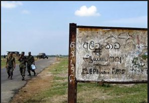
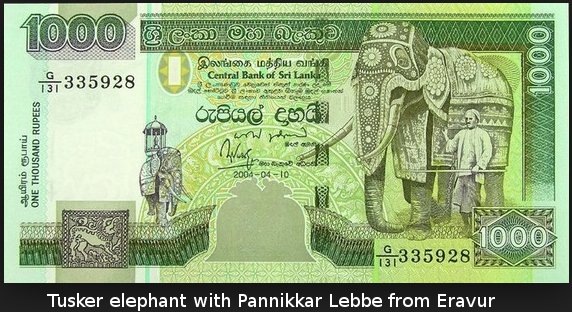
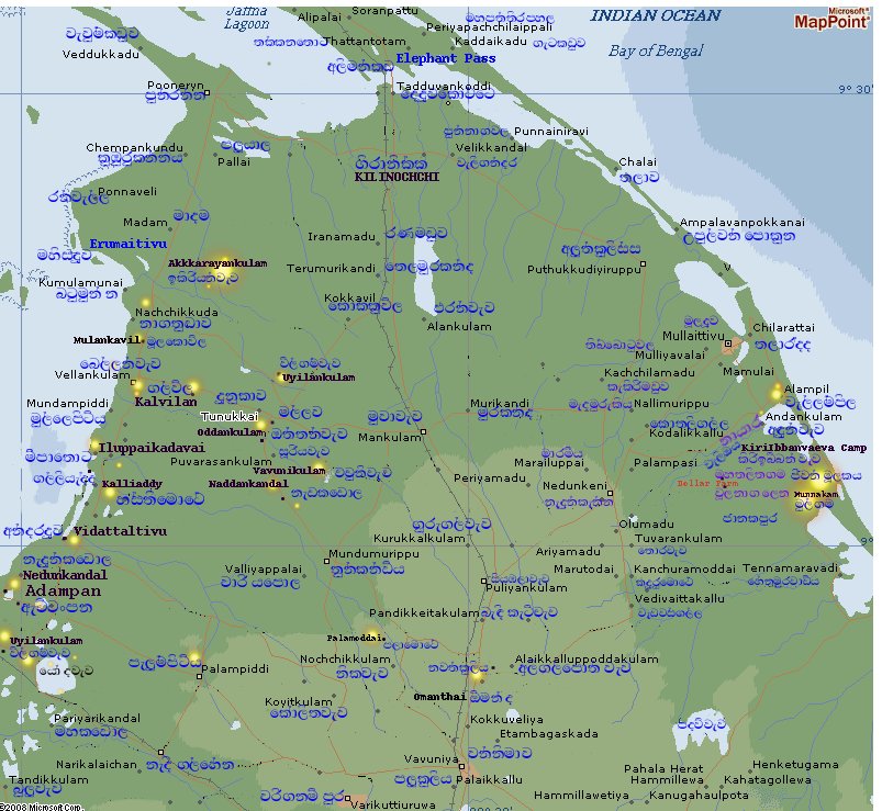
No comments:
Post a Comment